Making it safe and easy to bike, walk, and use public transport for everyday trips is key to rapidly cutting emissions in Wellington.
It’s vital that we create a connected network, so that more of us can get around more often in low carbon ways.
The following strategies, policies, plans and research provide the context for street improvements for pedestrians, public transport, and a safe, connected and high-quality bike network.
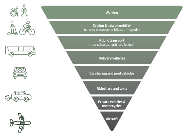
Sustainable transport hierarchy
Our sustainable hierarchy was first adopted in the Urban Growth Plan 2015 (now superseded by the Spatial Plan). The hierarchy prioritises movement by walking, biking, and public transport, so that our city’s streets work better for people.

Paneke Pōneke Bike Network Plan 2022
The bike network will connect suburbs to the city centre and destinations, helping to get people of various ages and abilities from where they live to where they work, study, shop, and play. Paneke Pōneke, Wellington’s bike network plan, was adopted in March 2022.
We consulted on the bike network plan between 2 November – 14 December 2021 as part of the Our City Tomorrow engagement. This engagement also included the draft District Plan and options for mass rapid transit routes through Let’s Get Wellington Moving.
Wellington Bike Network Plan Programme Business Case
In August 2022, Waka Kotahi NZ Transport endorsed the Paneke Pōneke Bike Network Programme Business Case, which supports Paneke Pōneke, Wellington's Bike Network Plan.
- Wellington Bike Network Plan Programme Business Case (1.6MB PDF)
- Peer Review Report for Wellington Bike Network Plan Programme Business Case (314KB PDF)
Bus priority action plan 2019
Wellington City Council and Greater Wellington Regional Council commissioned the draft plan to make buses more reliable and quicker on the busiest routes in Wellington city. It also looks at how walking and cycling can be made safer and easier on these routes, and opportunities to make the streets better places for people.
The draft plan was approved by councillors from both councils at their meetings on 11 and 12 December 2019.
Long-term Plan 2021-2031
The Long-term Plan updated the city outcomes and priority objectives. It also provided $226 million over 10 years to develop a bike network. This is supported by investments in Let's Get Wellington Moving, which will provide for safe biking in the city centre and key corridors connecting to the city centre.
Spatial Plan 2021
The Spatial Plan 2021 provides a blueprint for more housing to accommodate a growing population over the next 30 years. This includes supporting tens of thousands more people to live in the inner-city suburbs and within walking distance of the city centre and rapid transport stops.
A well-connected walking and biking network is key to accommodating more people in the city without adding to car congestion or putting pressure on our bus services.
Greater Wellington Regional Council, Wellington Regional Land Transport Plan 2021
This plan sets out the strategic direction for transport investment across the Greater Wellington region, including targets to reduce transport emissions and increase the proportion of people walking, biking, and using public transport.
Wellington Regional Land Transport Plan 2021
Parking Policy 2020
The Parking Policy provides a framework to guide future decision-making on the management of all Council-controlled parking spaces, and how parking supports achieving the vision for Wellington. The Parking Policy refers to the sustainable transport hierarchy, which gives highest priority to active modes of transport, such as walking, biking, and public transport. This means that when we make decisions on using road space, these active modes take a higher priority to parking.
Te Atakura First to Zero Blueprint and Implementation Plan 2019
We aim to become a net zero carbon city by 2050. Road transport emissions represent 34% of our city’s emissions – making them the single biggest source. Electric vehicles alone can’t solve this problem, given their relative expense. Making it safe and easy to bike, walk, and use public transport for everyday trips is key to rapidly cutting emissions in Wellington.
Te Atakura - First to Zero Blueprint and Implementation Plan 2019
Previous cycling strategic documents
- Wellington Cycle Network Strategic Case 2015: This outlines the challenges related to cycling and how achieving the objectives will benefit Wellingtonians.
- Cycling Framework 2015: This set out a decision-making process for the bike network and how it would be developed. It should be noted that design guidelines for what makes a safe bike lane are continually being developed and we expect to take account of current guidance as we plan improvements.
- Cycling Demand Analysis 2014: This research investigated how different types of cycling infrastructure is likely to affect the numbers of people choosing to cycle in Wellington and assessed the demand for improvements.